Call or Text Us Today

Dependable Land Surveying for:

HOMES, BUSINESSES, AND PUBLIC WORKS

Our licensed surveyors and cutting-edge tech mean precise, reliable results.

REQUEST A FREE QUOTE TODAY BY CALLING OR FILLING OUT OUR ONLINE FORM -->

SERVICES

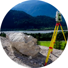
These surveys involve measuring and mapping the natural and manmade features of a land area, including contours, elevations, drainage patterns, vegetation, and structures. The resulting map can be used for planning and designing various construction projects.

These surveys establish the exact location of property lines and corners,and help to resolve any boundary disputes. The surveyors will mark the corners withmonuments or stakes, and provide a detailed map and legal description of the property boundaries.

An ALTA survey is a comprehensive survey that meets the standards set by the American Land Title Association. It provides detailed information on property boundaries, easements, rights-of-way, improvements, and other important features that can affect the ownership and use of the property.

These surveys modify existing property lines, which can be useful forcombining or separating parcels of land, resolving boundary disputes, or adjusting property boundaries to comply with zoning or building codes.

: Industrial surveys provide critical data for large-scale construction projects, such as factories, power plants, and transportation infrastructure. The surveyors will map the site, including any existing buildings, utilities, and natural features, and provide detailed information on elevations, drainage, and other factors that can affect the construction proces.

An elevation certificate is a document that establishes the
elevation of a building’s lowest floor relative to the base flood elevation. This information is used by insurance companies to determine flood insurance rates, and can be useful for property owners who want to protect their property from flood damage.

These surveys use aerial photographs and other remote sensing techniques to create detailed maps and models of the land. This can be useful for large-scale mapping projects, as well as for monitoring changes in the land over time.

Industries We Serve

ENERGY PROJECTS

EDUCATIONAL PROJECTS

COMMERCIAL PROJECTS

RESIDENTIAL PROJECTS

WIRELESS PROJECTS

ENVIRONMENTAL PROJECTS

GET INVOLVED